 |
|
||||||||||||||||||
|
|
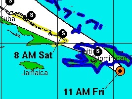
Haiti - FLASH : ERIKA changes direction and threatens more widely Haiti 28/08/2015 11:46:44
The storm should enter to the west of Santo Domingo then out that night or Saturday morning by the Dajabon - Cap Haitien corridor. The departments that should be the most affected are the Northeast, North, Northwest, Artibonite, Centre but also the West department threatening to disturb the Carifesta XII activities. Reports from an Air Force Reserve Hurricane Hunter aircraft indicate that maximum sustained winds are near 50 mph (85 km/h) with higher gusts. Some weakening is forecast this afternoon and tonight as Erika moves over land, followed by little change in strength through Saturday night. Note that the area of influence of Tropical Storm Erika extends outward to 240 km from its center. The National Meteorological Centre (CNM) of Haiti indicates that Erika could result in significant rain accumulations, , heavy swells and gusty winds abnormal in the territory, especially on the northern part. The CNM asks the inhabitants of the risk areas to remain very vigilant. ollow the progress of Erika in the next hour on HaitiLibre. See also : https://www.haitilibre.com/en/news-14970-haiti-erika-the-government-announces-measures-and-calls-for-vigilance.html https://www.haitilibre.com/article-14965-haiti-erika-haiti-en-alerte-orange-la-menace-est-serieuse.html https://www.haitilibre.com/en/news-14955-haiti-notice-storm-erika-should-affect-northern-haiti.html HL/ HaitiLibre
|
|


|
Why HaitiLibre ? |
Contact us |
Français
Copyright © 2010 - 2024 Haitilibre.com |