
|
|
||||||||||||||||||
| Download the revised decree and electoral calendar, published in the official journal |

|
|
|
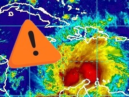
Haiti - FLASH : Matthew, Haiti in alert phase 1 01/10/2016 14:41:13
The National Hurricane Center of NOAA (National Oceanic and Atmospheric Administration), informs that the category 4 hurricane Matthew, is located 615 km south of Port-au-Prince, with maximum sustained winds of 220 km/h, and is now moving south at 4 km/h. "A faster motion toward the west should resume later today, followed by a turn toward the west-northwest by tonight. A turn toward the north-northwest is forecast on Sunday, with northward motion expected on Monday. On the forecast track, the center of Matthew will move across the central Caribbean Sea today and Sunday, and approach Jamaica and southwestern Haiti Sunday night and Monday," indicates for its part the NOAA. Hurricane-force winds extend outward up to 30 miles (45 km) from the center and tropical-storm-force winds extend outward up to 205 miles (335 km). Haiti is currently in alert phase 1 (Orange Vigilance), there is a watche from the southern border with the Dominican Republic to Mole Saint-Nicolas in the north-west. For its part the National Meteorological Centre (CNM) of Haiti indicates "Matthew has a strong rainfall capacity ranging from 200 to 300mm in the plains and more than 300mm on the heights. These accumulations of rain during the passage of Hurricane Matthew from Sunday to Tuesday could cause severe flooding, important mudslides and of flash floods all over the country especially on the departments of South, of Nippes, Grande-Anse, South East and West." The cirriform clouds continue to invade the country, warning signs generally, before a tropical cyclone. The wind is strengthening and sea conditions on the south coast are really chaotic. The latest forecast path show the passage of the eye of Hurricane Matthew a little further East (closer to the extreme south western tip of Haiti). So the South region of the country is under the threat of Hurricane conditions and the rest of the country under storm conditions. The SPGRD together with CNM and SEMANAH prohibits all cabotage operations in coastal areas in particular the country's southern coast and the Gulf of Gonâve until further notice. HL/ HaitiLibre
|
|


|
Why HaitiLibre ? |
Contact us |
Français
Copyright © 2010 - 2026 Haitilibre.com |