 |
|
||||||||||||||||||
|
|
Haiti - FLASH : Matthew approaches, Haiti in red vigilance 02/10/2016 07:09:59
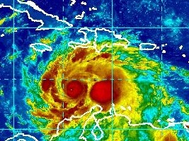
The Category 4 hurricane has maximum sustained winds of 240 km/h, and is currently moving toward the northwest at 7 km/h. Hurricane-force winds extend outward up 25 miles (35 km) from the center and tropical-storm-force winds extend outward up to 205 miles (335 km). The combination of a dangerous storm surge and large and destructive waves could raise water levels by as much as the following amounts above normal tide levels, 6 to 9 feet for the South coast of Haiti and 3 to 5 feet for the Gulf of Gonâve. Matthew is expected to produce total rain accumulations of 15 (380 mm) to 25 inches (635mm) over southern Haiti, with possible isolated maximum amounts of 40 inches (1016mm). Matthew is expected to produce total rain accumulations of 10 (254mm) to 20 inches (508mm) over eastern Jamaica, the Dominican Republic and eastern Cuba, with possible isolated maximum amounts of 25 inches (635mm). This rainfall will produce life-threatening flash floods and mud slides. If Matthew continues on its current trajectory Haiti should start to feel more strongly the effects of the hurricane in the next 24 hours. It should affect the South, Grande Anse and Nippes stronger, then up, the island of Gonâve should feel the effects, and the West, Artibonite and before leaving the territory, the Northwest... 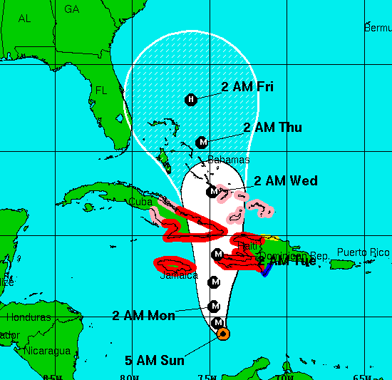 Red Vigilance For its part the National Meteorological Centre (CNM) of Haiti informs that the country is in Phase of Alert 1 (Vigilance Red), and that the convective cells associated with powerful Hurricane Matthew reinforce increasingly seriously and continue to move seriously on the country. Moreover, the winds and the dangerous sea conditions, especially on the south coast remain increasingly important. Threats of thunderstorm and gale force winds are confirmed particularly for the south of the country in the next 24 hours. Matthew has a strong capacity of rainfall ranging from 200 to 300mm in the plains and more than 300mm on the heights. These accumulations of rain during the passage of Hurricane Matthew from Sunday to Tuesday could cause severe flooding, important mudslidesand of flash floods all over the country especially on the southern departments, of Nippes, Grande-Anse, South East and West. Mobilization All government is mobilized, as well as the security forces to quickly assess the situation and coordinate response actions. Regional committees of civil protection are also mobilized to help at-risk populations, whose cooperation is highly desirable as to the application of safety regulations. The authorities are further accelerating the deployment of medicines and hygiene kits in the most risky areas. DPC indicated that in the South of 576 temporary shelters are available and can accommodate up to 88,252 people for a period of at least 3 days. The Minustah will deploy its staff in reinforcement and a United Nations Disaster Assessment and Coordination (UNDAC) team will arrive in Haiti on Sunday to immediately deploy in the south. Cabotage operations forbidden The SPGRD together with the CNM and SEMANAH prohibits all cabotage operations in coastal areas in particular the country's southern coast and the Gulf of Gonâve until further notice. Instructions - Stay tuned for Meteorological bulletins - Follow instructions issued by local authorities. - Put in a safe place important papers. - Prepare food kits. - Do not go to sea, avoiding the beaches and coast, protect boats. - Secure all that can be carried by the wind and which is outside the house, trash, tools, posters, lamps, decorative, bulbs. - Get down any heavy object highly placed antennas, signs... - Prepare to evacuate, the areas exposed to floods and landslides (seaside, gullies, rivers, mountain slopes, etc...) - Avoid areas subject to flooding and landslides (seaside, gullies, rivers, mountain slopes, etc...) - Do not cross rivers in spate under any circumstances. - Do not shelter near windows and wooded area. HL/ HaitiLibre
|
|


|
Why HaitiLibre ? |
Contact us |
Français
Copyright © 2010 - 2024 Haitilibre.com |