 |
|
||||||||||||||||||
|
|
Haiti - FLASH : Haiti under orange alert as MARIA approaches 20/09/2017 06:37:26
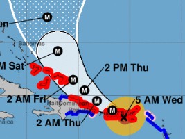
The trajectory of MARIA West-North-West to the North-West is expected to continue until today and, according to forecasts, move more towards northwest Thursday. According to the National Oceanic and Atmospheric Administration (NOAA), MARIA's eye will land in Puerto Rico in a few hours and will cross the island during the day and then MARIA will pass north of the northeast coast of the Republic Dominican tonight and Thursday. Unless there is a change in its trajectory, given the likely shift to the Northwest, the hurricane MARIA expected to pass north of Haiti on Thursday and Friday, could affect the country to a lesser extent However, strong swell, heavy rain and gusts of strong winds are expected in the northern departments. Maximum sustained winds are near 155 mph (250 km/h) with higher gusts. Maria is an extremely dangerous category 4 hurricane on the Saffir-Simpson Hurricane Wind Scale, and it should maintain this intensity until landfall. On Monday in Port-au-Prince, the Permanent Secretariat of Risk Management (SPGRD) launched the first phase of early warning at the level of yellow vigilance in anticipation of the passage of Maria. The center of MARIA should position itself on the coastal areas north of Haiti from Thursday morning. Even if its trajectory does not directly concern Haiti, its strong rainfall capacity would already threaten to strongly impact the Island as a whole as early as Wednesday and could cause severe floods and a stormy sea on the northern region. Yesterday, Tuesday at 11:00 am, the Permanent Secretariat of Risk Management (SPGRD) together with the Civil Protection Department (DPC) and the Hydro Meteorological Unit of Haiti (UHM) initiated the phase of Alert1 at level of vigilance Orange, on the northern regions of the country (ie risk of impact of moderate to strong intensity) and announces the activation of the National Risk Management Plan face the threats of heavy rains with the risk of rockfalls, strong swell, landslides and floods. The DPC is asking the population of the areas at risk to prepare to evacuate and stay tuned to the weather reports that will be broadcast throughout the passage of Maria near the northern coast of the country. See also : https://www.haitilibre.com/en/news-22154-haiti-flash-hurricane-maria-in-category-4-haiti-in-pre-alert-yellow.html https://www.haitilibre.com/en/news-22148-haiti-flash-maria-becomes-a-potentially-dangerous-hurricane.html SL/ HaitiLibre
|
|


|
Why HaitiLibre ? |
Contact us |
Français
Copyright © 2010 - 2024 Haitilibre.com |