 |
|
||||||||||||||||||
| Download the revised decree and electoral calendar, published in the official journal |
 |
|
|
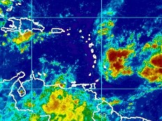
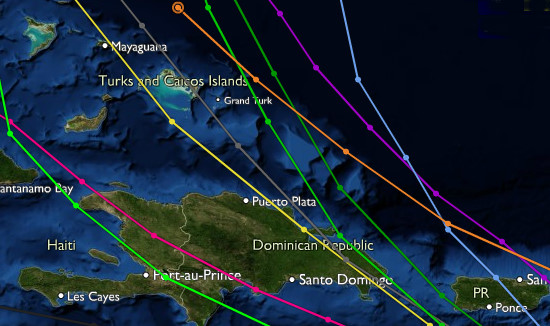
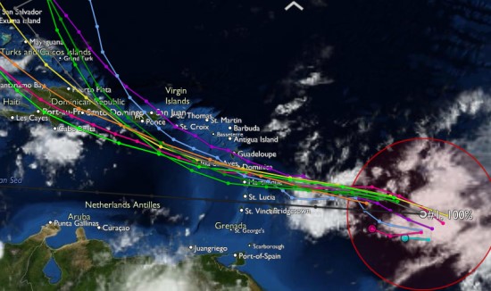
Haiti - Weather : Hurricane in formation 31/07/2011 10:19:20
Satellite images of this Sunday, July 31 (8:00 am - EDT) and National Oceanic and Atmospheric Administration (NOAA) buoy data indicate that the large and elongated low pressure system centered about 650 miles east of the northern windward islands continues to become better organized, and that it could develop into a tropical depression at any time. The probability that this system becomes in the next 24 to 48 hours, a tropical storm is nearly 100% It moves at this time to the west-northwestward near 15 mph. An air force reserve unit reconnaissance aircraft is scheduled to investigate this disturbance later this afternoon. However, given that it is only a hurricane in formation, the forecast models for this low pressure system are highly variable, the probabilities trajectories are highly variable. Most indicate a probable passage to the north of Haiti. The National Meteorological Centre of Haiti is closely monitoring the trajectory and evolution of this system. Note that the predictions of "Geophysical Fluid Dynamics Laboratory (GFDL) model" (in pink on the image) shows a trajectory passing over or near Port-au-Prince, and that of "Beta and Advection Model, Shallow (BAMS)" (in green on the image) a trajectory passing through the center of Haiti.
If the moving speed is keeping this system could be "close" or on Haiti on Wednesday or Thursday. HL/ HaitiLibre
|
|


|
Why HaitiLibre ? |
Contact us |
Français
Copyright © 2010 - 2026 Haitilibre.com |