 |
|
||||||||||||||||||
|
|
Haiti - Environment : ISAAC approaches, Haiti in Red (UPDATE 8h06 pm) 23/08/2012 07:17:01
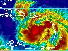
According to the NHC in Miami, Haiti should be affected by ISAAC between Friday afternoon and Saturday morning. A reconnaissance aircraft of the U.S. Air Force found that ISAAC was slightly weaker and farther south. Entire southern coast of the Dominican Republic, and all the coasts of Haiti are in hurricane warning, the north coast of the Dominican Republic is in tropical storm warning. Concerning the rain accumulation NHC indicates that on the island of Hispaniola otal rainfall accumulations could be 20 to 30 centimeters with maximum amounts of 50 centimeters. The National Meteorological Centre (CNM) of Haiti in its special bulletin #6 of Thursday, August 23, 2012 indicates that we are currently in Alert phase 2 at the level of Red Vigilance (ie risk of impact of intensity violent to extreme) and recalls the activation of the Plan PNGRD faces to the threats of strong winds, heavy rain and big seas with risk of landslides, mudslides and flooding throughout the country from Friday. The CNM indicates for its part, that according to the latest analysis of trajectory by computer, the center of ISAAC is located in the South Southeast of Puerto Rico and is likely to reach the island of Haiti (Hispaniola) from tonight. Update 9h35 The Prime Minister Laurent Lamothe convened of emergency, this Thursday, August 23 at 11:00 am, at the Emergency Operations Centre (COU), a meeting of SNGRD at the approach of Tropical Storm ISAAC on the Haitian territory, as President of SNGRD, the Chief of the Primature intends to mobilize a maximum the members of the Government around the necessity to take urgent measures to in order to face the imminent passage of the storm over the country. The government asks to the population to strictly follow the instructions of the authorities. https://www.haitilibre.com/en/news-6456-haiti-environment-isaac-the-prime-minister-declared-the-permanence.html Update 11h22 At 11:00 am the tropical storm ISAAC is located at 15.6N 65.4W, or 815 km south southeast of Port-au-Prince, 575km east south-east of Santo Domingo, 320km south southeast of San Juan Puerto Rico, it always moves towards West but is now turning towards the island of Hispaniola, the speed increased to 24km/h, the maximum speed of the winds is 65km/h. Update 2h26 pm The CST Miami just confirmed that ISAAC now moves West Northwest at a speed of 24km/h, the tropical storm is located at 16.0N 66.4W or 691km south southeast of Port-au Prince. The Miami Center also indicates that the center center of ISAAC will continue to pass South of Puerto Rico today, and near the south coast of the Dominican Republic and Haiti on Friday. Winds 65km/h with higher gusts. Strengthening is forecast during the next 48 hours and ISAAC could become a hurricane as it nears the Dominican Republic and Haiti. Update 5h25 pm At 5pm ISAAC is located at 16.0N 67.1W, it always moves towards West Northwest, its speed of displacement increased to 26km/h. The storm is located 405km south-east of Santo Domingo, 285km south southwest of San Juan, Puerto Rico, and 636km south southeast of Port-au-Prince. Minister of Communication, Ady Jean Gardy announced that for the moment all airport operations continued normally, but all cabotage operations are prohibited. Dominican Republic airports will be closed from midnight tonight until 6 am Friday. Update 8h02 pm At 8pm the center of ISAAC s located in an axis between the Dominican Republic and Puerto Rico (16.2N 67.8W), the storm is heading towards West Northwest at a speed of 26km/h and should enter in the waters of the Dominican Republic tonight and according to current forecast track, enter on the Haitian territory tomorrow afternoon, but the first effects should begin to be felt tomorrow morning because the winds now extend up to 295km from its center, mainly in the North-East of it. 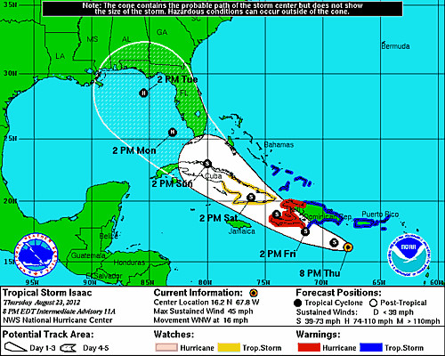 The CNM together with the SPGRD and the DPC asks the population in the areas at risk to remain vigilant and strictly implement the following safety precautions : - Be prepared to evacuate if necessary, areas exposed to floods and landslides (seaside, gullies, rivers, mountain slopes, etc...) - Do not cross rivers in spate under any circumstances. - In case of severe thunderstorms, do not shelter near windows and wooded area. More information to come... S/ HaitiLibre
|
|


|
Why HaitiLibre ? |
Contact us |
Français
Copyright © 2010 - 2024 Haitilibre.com |