|
||||||||||||||||||
|
|
Haiti - Environment : Sandy, indirect effects for Haiti (UPDATE) 24/10/2012 07:44:31
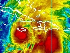
5 a.m. Sandy is localized Wednesday, October 24, 2012 at 5 am to 16.3 degrees north latitude and 77.0 degrees west longitude or about 190 km south of Kingston Jamaica, 475km south southwest of Guantanamo Cuba, 407km south-west of Les Cayes. Sandy moves northward at about 22km/h. Maximum winds blowing at 110km/h with gusts well above. The storm winds blowing at 220km from the center. 11 a.m. Sandy, now a hurricane, is localized Wednesday, October 24, 2012 at 11 am to 17.1 degrees north latitude and 76.7 degrees west longitude or about 100 km south of Kingston Jamaica, 380km south southwest of Guantanamo Cuba, 336km south-west of Les Cayes. Sandy moves northward at about 20km/h. Maximum winds blowing at 130km/h with gusts well above. The storm winds blowing at 220km from the center. The National Meteorological Centre (CNM) recalls that "according to the latest numerical analyzes, Sandy has a strong capacity pluviometric and could dump between 150 to 300 mm of rain on the plains and 500 mm on the mountains." The CNM informs that the Caribbean basin remains under the influence of tropical storm Sandy. Indeed, the island of Haiti could know a weather disturbed by the indirect effects of the storm in the form of grain (rain and wind) and thunderstorm over the entire south frontage and few violent on the other departments of the country. Wednesday the weather will be cloudy to covered during the day ; Rain and thunderstorms are expected in mid-day and evening. Thursday, a few sunny periods in the morning, rain and thunderstorms in the evening. Consequently, the SPGRD maintains this Wednesday, Oct. 24, 2012 to 6 a.m the alert phase at the level of Orange Vigilance, especially for the departments of the West, South, South East, Nippes and Grand Anse (at 8 a.m. throughout the country), against the threat of high winds, heavy rain and heavy seas with risks of rockslide, landslides and floods. At 8 a.m., the level of Vigilance Red was decreed for the departments of the south, south-east, the Nippes, West and of the Grand-anse and Orange for the rest of the departments. Cabotage Cabotage activities are prohibited on the south coast of Haiti and the Gulf of Gonâve, and vessels must remain in their port or in sheltered waters until further notice. Flights However, it is imperative that local flights to and from the southern coast exercise caution because, to the extent that the system is close to Jamaica, gusts may happen at any time throughout the southern peninsula of Haiti. HL/ HaitiLibre
|
|
|
Why HaitiLibre ? |
Contact us |
Français
Copyright © 2010 - 2024 Haitilibre.com |


