
|
|
||||||||||||||||||
| Download the revised decree and electoral calendar, published in the official journal |

|
|
|
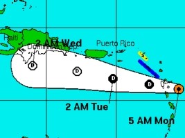
Haiti - NOTICE : Danny should affect the South coast of Haiti (UPDATE 11h00 a.m.) 24/08/2015 07:04:18
The National Hurricane Center (NHC) informs that the first hurricane of the region, known as Danny, was Monday morning at 5:00 at 15.8N 60.5W, or 125km east of the southern tip of Guadeloupe. It is currently moving at 15km/h and is expected to pass the Caribbean Arc in the coming hours, following a Western path. On Sunday, the National Meteorological Center (CNM) of Haiti said that "Danny can probably regress to a tropical depression before reaching the coast of the Dominican Republic in the next 48-72 hours." That same day in Haiti, the National Emergency Operations Centre (COUN), held a 4th information meeting around Danny and security measures. For its part the National Hurricane Center indicates that after the passage on the Caribbean Arc "Danny is expected to become a tropical depression by this evening, and degenerate into a remnant low tonight or on Tuesday. According to the current trajectory and unless changes Wednesday, August 26, the departments of South-East and South in Haiti, should feel its effects, rain and winds. The current forecast includes winds of 50km/h gusting to 65km/h. Update 8h00 a.m. : The National Hurricane Center (NHC) confirmed at 8:00 am that Danny weakens to a tropical depression. The path remains the same. Currently located 30 km south of Guadeloupe it moves at 19km/h towards the West. Update 11h00 p.m. Reports from an Air Force Hurricane Hunter plane indicate that Danny has degenerated into a trough of low pressure. At 1100 AM AST (1500 UTC), the remnants of Danny were located near latitude 16.0 North, longitude 62.0 West. The remnants are moving toward the west near 19 km/h, and this general motion is expected to continue for the next day or two. Maximum sustained winds have decreased near 45 km/h with higher gusts. The trough is expected to dissipate during the next couple of days. The Civil Protection Directorate (DPC) announced that "The remains of the hurricane Danny could cause heavy rains and flooding by Wednesday." The events of Carifesta XX of Port-au-Prince should not be affected if the trajectory expected this Monday morning does not change. The tropical-storm-force winds extend outward up to 95 km from the center. HaiitLibre continues to monitor the movement of this system carefully to keep you informed on the progress of this storm. HL/ HaitiLibre
|
|


|
Why HaitiLibre ? |
Contact us |
Français
Copyright © 2010 - 2026 Haitilibre.com |