
|
|
||||||||||||||||||
| Download the revised decree and electoral calendar, published in the official journal |

|
|
|
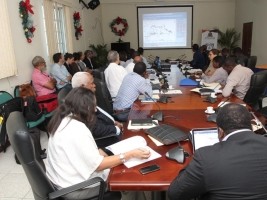
Haiti - Politic : Follow-up of the mapping project for the management and prevention of natural risks 20/01/2019 07:44:10
This week, the Directorate of Regional Planning, Local and Regional Development of the Ministry of Planning and External Cooperation (MPCE) received the 4th meeting of the Monitoring Committee of the Natural Hazard Mapping Project, Flooding, land movement and soil degradation. Representatives of the European Union, the United Nations Development Program (UNDP), Ministry Staff and other government agencies took part in this meeting with the aim of producing multi-hazard maps which will be used for the management and prevention of natural hazards. For the moment this project is supported by the UNDP through a financing of the European Union for the departments of North-West and Artibonite (Gros Morne). It aims to reduce the impact of natural disasters in these regions and especially on the livelihoods of the population, through a reorientation of land use, based on the consideration of natural hazards and environmental and economic potential. of these spaces. Remember that this project is the realization of the concern of the government, with the support of the UNDP, to develop a national methodology for the reduction of natural risks in Haiti, while raising awareness and strengthening local actors for its application in the projects of spatial planning and urban development. See also : HL/ HaitiLibre
|
|


|
Why HaitiLibre ? |
Contact us |
Français
Copyright © 2010 - 2026 Haitilibre.com |