
|
|
||||||||||||||||||
| 2026-2027 Electoral Calendar, latest official version |

|
|
|
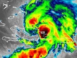
Haiti - Storm Isaias : Haiti still under threat, be careful 30/07/2020 17:13:19
At 5:00 p.m. the center of tropical storm Isaias was located near latitude 19.5 north and longitude 70.6 west, or 35km southeast of Puerto Plata, 169 km east of Cap Haitien. Isaias is moving northwest at near 20 mph (31 km/h) and northwestward movement with some decrease in forward speed is expected over the next few days. According to forecasts, the center of Isaias will move close to the southeastern Bahamas by the end of the night. Isaias is expected to be near the central Bahamas on Friday evening and move near or over the northwestern Bahamas and near southern Florida on Saturday. Maximum sustained winds are near 95 km/h with higher gusts. Strengthening is expected approximately the next day, and Isaias is expected to become a hurricane on Friday or Friday night. Tropical storm force winds extend outward up to 390 km from the center. According to the trajectory analysis of several models, the Center of the system should cross the Dominican Republic during the day of Thursday and the northern region of the island of Haiti in the evening. Therefore, thunderstorm rain showers ranging from moderate to heavy reaching between 75 and 125 mm in the plains and 200 mm especially in mountainous areas. They are likely to occur from sustained gusts of wind and heavy seas conditions are also expected in the North region and the Gulf of Gonâve from today to tomorrow. Consequently, the General Directorate of Civil Protection, the SPGRD in conjunction with the UHM maintained the activation of the National Risk and Disaster Management Plan with an Orange Vigilance level (i.e. Risk of moderate to strong impacts) on the country. In relation to the dangerous sea conditions that will be installed especially in the northern sector of the island of Haiti. SEMANAH together with the UHM announces the temporary ban on all cabotage operations on the northern coastal regions and the Gulf of Gonâve. The SPGRD of concert with the UHM and the DGPC also asks the Haitian population to exercise caution and to listen the weather reports of the UHM and the advice of the authorities of their respective zones to know the behaviors to adopt during the passage of this cyclonic event. Tropical storm ISAIAS is about to hit the country, especially in its northern region. Here are some guidelines to follow : - Stay tuned to Meteorological bulletins; - Stay tuned to instructions issued by local authorities; - Put your important papers in a safe place; - Prepare your emergency kit with food and water for at least three days; - Prepare to evacuate if you live in an area exposed to the risk of flooding and landslides: (seaside, ravine, river, mountainside, etc.); - Avoid crossing flooded rivers under any circumstances; - In the event of thunderstorms and strong winds, do not take shelter near windows and in wooded areas; - Prune the trees near the house; - Lower any heavy object placed high and not secure: antennas, signs and others; - Secure the animals. HL/ HaitiLibre
|
|


|
Why HaitiLibre ? |
Contact us |
Français
Copyright © 2010 - 2026 Haitilibre.com |