|
||||||||||||||||||
| Download the revised decree and electoral calendar, published in the official journal |
|
|
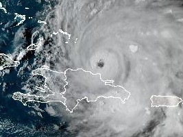
Haiti - FLASH : First effect of Hurricane Fiona on Haiti 19/09/2022 18:19:53
"Hurricane Fiona passes over the north coast of the island of Haiti. The rain continues to fall in several municipalities in the North and North-East departments of the country, in some places it is light, in some places it is heavy. And the sea is starting to get rough," said the Directorate of Civil Protection (DPC). At the time of writing the center of Fiona was located at sea 215 kilometers northeast of Haiti, which causes rough seas, and a cloud band attached to Fiona is over Haiti causing rain. Let's recall that Haiti is still at the level of Yellow Vigilance (i.e. risk of impact of Low to moderate intensity) in the face of the threats of heavy rains, strong winds and high seas during the passage of this system from Monday to Tuesday in the region. In relation to the dangerous sea conditions which are specially provided for in the departments of North, South and North-West of the Island of Haiti, SEMANAH in concert with the UHM announces the temporary ban on all operations of cabotage, particularly in the coastal regions of these departments. At 500 PM AST (2100 UTC), the center of Hurricane Fiona was located near latitude 20.1 North, longitude 69.8 West. Fiona is moving toward the northwest near 10 mph (17 km/h). This general motion is expected to continue through tonight, followed by a turn toward the north-northwest on Tuesday and to the north on Wednesday. On the forecast track, the center of Fiona will pass near or to the east of the Turks and Caicos on Tuesday. Maximum sustained winds have increased to near 100 mph (155 km/h) with higher gusts. Steady strengthening is expected during the next couple of days, and Fiona is forecast to become a major hurricane on Tuesday. Hurricane-force winds extend outward up to 30 miles (45 km) from the center and tropical-storm-force winds extend outward up to 140 miles (220 km). The estimated minimum central pressure is 972 mb (28.71 inches).
|
|
|
Why HaitiLibre ? |
Contact us |
Français
Copyright © 2010 - 2026 Haitilibre.com |


