
|
|
||||||||||||||||||
| Download the revised decree and electoral calendar, published in the official journal |

|
|
|
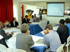
Haiti - Technology : Launch of the project of aerial photographic coverage of Haiti 24/01/2014 10:11:44
Tuesday, Engineer Hertz Obas, the Director General of the Ministry of the Interior and Territorial Communities (MICT), accompanied, among others by, Ruthlande Anglade, Director of Local Authorities and Dr. Yolaine Surena of the DPC proceeded to hotel Montana, to the launch of the project of aerial photographic coverage of Haiti. In his speech for the occasion, Hertz Obas welcomed the contribution of the responsibles of the DPC This project of photographic coverage of the entire country constitutes a coherent working tool in the context of actions and plans for development. It will also wllow to identify and act to counteract and anticipate natural hazards," thanking the World Bank for its financial contribution 2.89 million U.S. dollars within the framework of this project started this month, which will be realized in two phases over a period of about 10 months. The projet of aerial photographic coverage of all of Haiti, was entrusted to the National Geographic Institute of France (IGN France International) in order to develop soil maps of high accuracy. The information that will be collected, will allow Haiti to develop an urban database to date, which will allow among other things, to observe the land covers. These data will also serve to MICT for a better management of cadastre and land use in general and will give the Haitian government, the opportunity to observe the impact of projects, actions and understand the hazards related to natural risks to reduce them for a better adequacy of the phase of response. Haiti's new photographic aerial map should be ready in November 2014. Have also also took part in the ceremony of Representatives of the Ministry of Agriculture, the World Bank, of the Ministry of Planning, of the European Union, of "National Center for Geo-Information Space" (CNIGS), of the United Nations Programme for Development (UNDP) and the European Commission Humanitarian Office (ECHO). HL/ HaitiLibre
|
|


|
Why HaitiLibre ? |
Contact us |
Français
Copyright © 2010 - 2026 Haitilibre.com |