
|
|
||||||||||||||||||
| Download the revised decree and electoral calendar, published in the official journal |

|
|
|
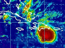
Haiti - FLASH : Risk of formation of a hurricane in the next 48 hours (UPDATE 8:00 a.m.) 01/08/2016 06:56:41
UPDATE 8h00 a.m. : The U.S. National Hurricane Center informs that regardless of development, locally heavy rainfall and gusty winds, perhaps to tropical storm force, are likely along the southern coast of the Dominican Republic and Haiti today. Now the risks of formation of a hurricane through 48 hours are 80%, through 5 days to 90%. === Thunderstorm activity associated with a strong and fast-moving tropical wave located over the east-central Caribbean Sea about 200 miles south of the Dominican Republic has increased and become significantly better organized overnight. Although this system still lacks a closed surface circulation, recent satellite-derived surface wind data and ship observations indicate that tropical-storm-force winds of 40 to 45 mph are occurring on the northern and eastern areas of the large disturbance. If this recent development trend continues, then a tropical storm could form later today when the wave moves into the central Caribbean Sea, or by early Tuesday as it approaches Jamaica and moves into the western Caribbean Sea. Locally heavy rains and gusty winds are expected over Hispaniola this Monday, and reaching Jamaica and Cuba by late Monday as the system moves westward at 20 to 25 mph. Interests in these areas and elsewhere in the western Caribbean Sea should continue to monitor the progress of this strong disturbance. The risks of formation of a hurricane through 48 hours are 70%, through 5 days to 80% indicates the U.S. National Hurricane Center. For its part, the National Meteorological Centre (CNM) of Haiti announces : "The twentieth Tropical wave of the season is located south of the Dominican Republic this morning. This system proves to be very threatening for the Caribbean region mainly for the island of Haiti, Jamaica and Cuba this afternoon and tonight - Cloudy weather in some places with strong winds during the day ; - Acceptable temperatures during the day; pleasant to cool overnight ; - Heavy showers accompanied by thunderstorms and strong winds are expected in the country early this afternoon. Tuesday : Time cloudy during the day; thundershowers still possible at times and places. Wednesday: Partly cloudy during the day; stormy periods with the possibility of rain and thunderstorms in the afternoon." The Civil Protection Department (DPC) has issued the following message "Meteyo prevwa gwo gwo lapli sou peyi a pou jounen an, ki ka lakòz inodasyon, glismann teren ak deboulonnay tè. Meteyo prevwa gwo gwo lapli, gwo kout van ak lanmè ajite pou jounen an, pran prekosyon si w rete nan zòn danje." SL/ HaitiLibre
|
|


|
Why HaitiLibre ? |
Contact us |
Français
Copyright © 2010 - 2026 Haitilibre.com |