
|
|
||||||||||||||||||
| Download the revised decree and electoral calendar, published in the official journal |

|
|
|
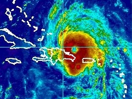
Haiti - FLASH : First effects of MARIA on Haiti 21/09/2017 06:09:21
This Thursday morning at 5:00 am, the eye of the hurricane MARIA Category 3 on the scale of Saffir-Simpson hurricane wind (winds of 178 to 210 km/h), was located near latitude 19.8 North and 68.4 West longitude or 125 km North of Punta Cana (East of the Dominican Republic). According to the National Oceanic and Atmospheric Administration (NOAA), MARIA's trajectory is oriented towards the Northwest and the Hurricane moves at a speed of 9 mp/h (15 km/h), and this general motion is expected through tonight. A turn toward the north-northwest is forecast on Friday. On the forecast track, Maria will continue to pass offshore of the northeastern coast of the Dominican Republic today. Maria should then move near the Turks and Caicos Islands and the southeastern Bahamas tonight and Friday. According to the National Center of Meteorology (CNM) of Haiti "According to the models of forecast of trajectory, the eye of Maria should be this Thursday to more than 300 km to the North-East of the city of Cap-Haitien. However, although the eye of MARIA will not pass directly on Haiti, its cloudy spiral band is likely to cause heavy rain from 100 to 150 mm in the country, causing flooding, landslides, as well as heavy sea conditions, and strong gusts of winds sustained including over the departments of Northeast, North, Northwest, Central and Artibonite at the passage of MARIA from this Thursday." "Heavy rains are currently falling over several communes of North-East Department as well as the city of Cap-Haitien. Light to moderate intermittent rains at Marmelade and Ennery. Rain to Gros Morne. Heavy rains have been falling on Milot since that night. Intermittent rain now," inform us this Thursday morning the Directorate of Civil Protection (DPC). Compared to the dangerous sea conditions expected on Thursday and Friday, the UHM together with the SPGRD and the DPC is calling on the SEMANAH authorities to prohibit cabotage operations on all the northern coasts of the country from today. The Departments of North, North East, Artibonite and Center were placed this Thursday morning in orange vigilance and the department of the North West in yellow vigilance. See also : HL/ HaitiLibre
|
|


|
Why HaitiLibre ? |
Contact us |
Français
Copyright © 2010 - 2026 Haitilibre.com |