
|
|
||||||||||||||||||
| 2026-2027 Electoral Calendar, latest official version |

|
|
|
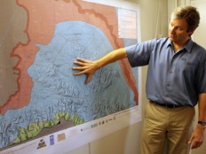
Haiti - Reconstruction : Macroseismic zoning maps for Port-au-Prince 25/02/2011 07:14:51
Within the framework of the risk reduction of natural disasters project and more particularly in the context of attenuation of earthquake threat, the United Nations Development Programme (UNDP), delivered to the Haitian institutions the macroseismic zoning maps of Port-au-Prince, a crucial tool for all projects building in Haiti. Developed in collaboration with the National Laboratory of Building and Construction, the Bureau of Mines and Energy, the National Center for Geospatial Information, the University of the Texas as well other international partners, this tool allows to identify the areas where the basement amplifies the vibrations of an earthquake. "To adapt to the seismic threat, we must know two things: first, the force, the intensity of this threat, so what will be the ground vibration when there is an earthquake. Second, we must know the type of soil on which we build because some soils amplify the vibrations," said Eric Calais, a seismologist commissioned by UNDP to assess the seismic risks that threaten Haiti and establish a strategy so that the local authorities can prevents of the best way a new disaster. "We didn't have this type of information in Haiti before January 12, but now since the beginning of the year, we have it and, it is necessary to use this information". Once quantified, these basic informations are used by engineers and architects who will size a house, for example by deciding the amount of reinforcement, the concrete quality, the thickness of the wall or column size. This information allows not only to dimension a building in a reasonable way but also to quantify the cost of it, a cost that varies depending on the degree of amplification of the vibration of each zone. The macroseismic zoning map is preliminary and present some uncertainties but remains of crucial importance because the decisions, the thinking and planning have already begun "It is important today to have such a tool even if it is not the final product, but it is very valid and worthwhile," explains Eric Calais "In addition of Port-au-Prince, it is also necessary to perform this same work on all other urban concentrations that are equally exposed to the earthquake threat and which are to a short distance, of a major seismic fault so they should also have this internal information" By mid-2012, a new generation of seismic zoning maps will be produced. This update requires one year of work and $1.5 million. The Ministry of Public Works will be the technical director of this operation in partnership with the Ministry of Plan. The government and all Haitian institutions have a key role in the compliance of the construction standards and the taking in account of the technical tools available to all actors involved in construction projects. "Right now in Haiti, there are no building codes or earthquake standards but we are working and we will produce a guide in the coming months," said a source at the Ministry of the Public Works. "However, the Ministry of the Public Works has authorized the use of international building codes in the construction projects in Haiti. With these tools and the seismic zoning maps that we recently delivered, we have all the ingredients to be able to size the infrastructure correctly vis-à-vis the seismic threat". The organizations and agencies that develop or that fund the construction projects have a real responsibility vis-à-vis the reduction of the vulnerability to earthquakes and other natural threats. "Any type of construction is subject to the seismic threat. It is therefore vital that local and international organizations include in their conditions of approval for the construction projects, the conditions, of respect of the seismic threat as we know," asserts Eric Calais. See also: HL/ HaitiLibre /UNPD
|
|


|
Why HaitiLibre ? |
Contact us |
Français
Copyright © 2010 - 2026 Haitilibre.com |