
|
|
||||||||||||||||||
| 2026-2027 Electoral Calendar, latest official version |

|
|
|
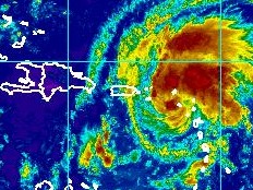
Haiti - Weather : Irene approaches, Haiti in red 21/08/2011 12:41:29
In the night of Saturday to Sunday, Irene, a large tropical wave became a tropical storm. Its current trajectory threatens all the Greater Antilles including Puerto Rico, the Dominican Republic, Haiti and Cuba. The National Meteorological Center (CNM) informs that the analysis of different forecasting models shows that Irene has the potential to become a Category 1 hurricane before reaching Haiti. To 10am, this Sunday, the center of the Tropical Storm Irene was located to 17.0 degrees north and 63.2 degrees West. To 982 km (610 miles) southeast of Port au Prince with sustained winds (maximum) of 85 km/h (50 mi/h). Irene is currently moving at 32 km/h (20 mph) along a trajectory West-Northwest, this motion is expected to continue for the next couple of days with a gradual decrease in forward speed. Irene will pass near puerto rico tonight or early monday and could hit the Dominican Republic and Haiti Monday or Tuesday. The area of influence of this system is of 240km (150 miles) of center, mainly to the north of the center. Most forecast models provide the passage of Irene on Haiti. Consequently, the alert level in Haiti is passed to red this Sunday, August 21, 2011 at 10:00 am (ie risk of impact of intensity violently to extreme, persistent threats of heavy rain, strong gusts of wind, with risks of rockfalls, landslide and flood, especially for the departments of South, Southeast, Grand-Anse, Nippes, West, of Centre and of the Artibonite. Following the current trajectory, Irene is located at: 377 km (234 mi) of Ponce (Puerto Rico) 573 km (356 mi) of Punta Cana 735 km (457 mi) of Santo Domingo 982 km (610 mi) of Port-au-Prince 1,000 km (621 mi) of Jacmel 1,127 km (700 mi) of Les Cayes Read also for the trajectories : https://www.haitilibre.com/en/news-3628-haiti-weather-irene-is-coming.html HL/ HaitiLibre
|
|


|
Why HaitiLibre ? |
Contact us |
Français
Copyright © 2010 - 2026 Haitilibre.com |