|
||||||||||||||||||
| Download the revised decree and electoral calendar, published in the official journal |
|
|
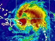
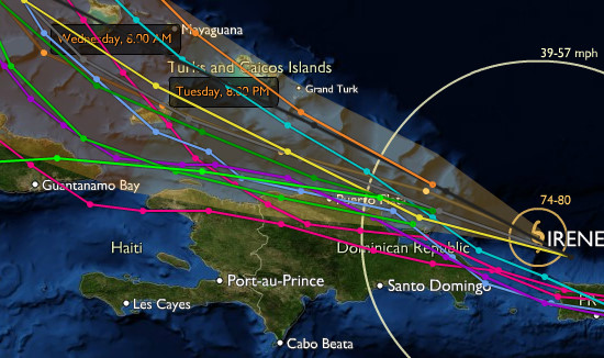
Haiti - Irene : Only the coastal regions to the north, could be affected 22/08/2011 12:42:36
The passage of Irene could be relatively "less serious" than originally planned https://www.haitilibre.com/en/news-3628-haiti-weather-irene-is-coming.html , because of its change of trajectory towards the North. Irene is currently moving at 20 km/h (13 mph) along a trajectory West Northwest, following the current trajectory, its center is expected to pass just north of the island of Hispaniola later today or early Tuesday. In Haiti, the most affected area could extend from the West side, Môle Saint-Nicolas to the Dominican border, east side. To 10am, this Monday, the center Irene was located to 19.2 degrees north and 67.5 degrees West. To 495 km (308 miles) Southeast of Cap Haitien with sustained winds (maximum) of 130 km/h (80 mi/h), with higher gusts. Winds extend outward up to 45 km (30 mi) from the center. Tropical-storm-force winds extend outward up to 295 km (185 mi), mainly to the northeast of the center. The National Meteorology Centre in conjunction with the Maritime and Navigation Service of Haiti (SEMANAH) prohibits cabotage operations throughout the north coast of Haiti until further notice. This measure of restriction could be extended on the south coast and the Gulf of Gonave depending on the tendency of the system.
See also : https://www.haitilibre.com/en/news-3635-haiti-irene-threat-on-the-north-of-haiti.html https://www.haitilibre.com/en/news-3631-haiti-weather-irene-approaches-haiti-in-red.html https://www.haitilibre.com/en/news-3628-haiti-weather-irene-is-coming.html HL/ HaitiLibre
|
|
|
Why HaitiLibre ? |
Contact us |
Français
Copyright © 2010 - 2026 Haitilibre.com |


