
|
|
||||||||||||||||||
| Download the revised decree and electoral calendar, published in the official journal |

|
|
|
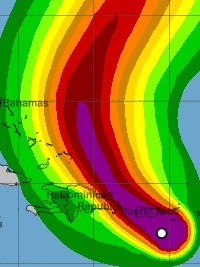
Haïti - FLASH : Storm Fiona is expected to become a hurricane 18/09/2022 06:16:35
According to the NOAA (National Oceanic and Atmospheric Administration) at 500 AM AST (0900 UTC), the center of Tropical Storm Fiona was located near latitude 17.1 North, longitude 65.8 West. Fiona is moving toward the west-northwest near 8 mph (13 km/h). A northwestward motion is expected to begin later today and continue through Monday, followed by a turn toward the north-northwest on Tuesday. On the forecast track, the center of Fiona will approach Puerto Rico this morning, and move near or over Puerto Rico this afternoon or evening. Fiona will then move near the northern coast of the Dominican Republic tonight and Monday, and near or to the east of the Turks and Caicos Islands on Tuesday. Maximum sustained winds are near 65 mph (100 km/h) with higher gusts. Strengthening is forecast, and Fiona is expected to become a hurricane before reaching the southern or southwestern coast of Puerto Rico later today. Additional strengthening is expected on Monday and Tuesday while Fiona moves near the Dominican Republic and over the southwestern Atlantic. Tropical-storm-force winds extend outward up to 140 miles (220 km) from the center The estimated minimum central pressure based on earlier aircraft data is 994 mb (29.36 inches). Hurricane conditions are expected across portions of Puerto Rico today, and are expected in portions of the Dominican Republic tonight and Monday. Heavy rains from Fiona will continue across Puerto Rico through tonight and occur over the Dominican Republic later today into Monday. These rainfall amounts will produce life-threatening flash floods and urban flooding across Puerto Rico and portions of the eastern Dominican Republic, along with mudslides and landslides in areas of higher terrain. Fiona is forecast to strengthen after moving away from Puerto Rico and the Dominican Republic. Haiti : Given the trajectory of Fiona, Haiti should not be directly affected, but winds up to 50 km/h and rains are expected in several regions of the country, with a risk of flooding and flooding of rivers. The Hydro Meteorological Unit of Haiti (UHM) predicts that this disturbance is likely to generate sustained, spontaneous gusts of wind, heavy stormy showers ranging from 70 to 100 millimeters of rain in Haiti and heavy sea conditions ; and that consequently the UHM of the Ministry of Agriculture, Natural Resources and Rural Development (MARNDR) in concert with the General Directorate of Civil Protection and the SPGRD of the National Risk and Disaster Management Plan maintains the level of Yellow vigilance (i.e. risk of impact of Low to moderate intensity) in the face of threats of heavy rains, strong winds and heavy rains during the passage of this system from Monday to Tuesday. The SPGRD in concert with the UHM, the DGPC and the SEMANAH also asks the Haitian population to exercise caution and to stay tuned to the weather reports from the UHM and the advice of the authorities in their respective areas to know the behavior to adopt during the passage of this hurricane event. Instructions :
The Maritime and Navigation Service of Haiti (SEMANAH) continues to prohibit all maritime activity until further notice. SEMANAH asks all sailors, fishermen, boat captains and the population to respect the advice of their maritime representatives. See also : https://www.haitilibre.com/en/news-37663-haiti-flash-fiona-approaching-haiti-on-yellow-alert.html https://www.haitilibre.com/en/news-37647-haiti-flash-tropical-storm-fiona-heads-to-haiti.html HL/ HaïtiLibre
|
|


|
Why HaitiLibre ? |
Contact us |
Français
Copyright © 2010 - 2026 Haitilibre.com |