
|
|
||||||||||||||||||
| Download the revised decree and electoral calendar, published in the official journal |

|
|
|
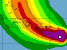
Haïti FLASH : Fiona approaching, Haiti on yellow alert 17/09/2022 06:21:32
According to the NOAA (National Oceanic and Atmospheric Administration) at 500 AM AST (0900 UTC), the center of Tropical Storm Fiona was located near latitude 16.4 North, longitude 63.3 West. Fiona is moving toward the west near 13 mph (20.9 km/h). A westward to west-northwestward motion with a decrease in forward speed is expected through Sunday night. A turn toward the northwest is forecast early next week. On the forecast track, the center of Fiona is expected to move near or just south of the Virgin Islands and Puerto Rico today through Sunday, and approach the southern or eastern coast of the Dominican Republic Sunday night and Monday. Maximum sustained winds are near 60 mph (96.5 km/h) with higher gusts. Some strengthening is forecast, and Fiona could be near hurricane strength when it moves near Puerto Rico and the Dominican Republic this weekend. Tropical-storm-force winds extend outward up to 125 miles (201 km) from the center. The estimated minimum central pressure is 1000 mb (29.53 inches). The UHM of the Ministry of Agriculture, Natural Resources and Rural Development (MARNDR) in concert with the General Directorate of Civil Protection and the SPGRD of the National Risk and Disaster Management Plan maintains this Friday, September 16, 2022 at 6:00 a.m. PM the level of Yellow Vigilance (i.e. risk of impact of Low to moderate intensity) in the face of threats of heavy rains and strong winds during the passage of this system north of the Island from Sunday evening to Monday. Heavy rains from Fiona will spread west to British and U.S. Virgin Islands and Puerto Rico today, the Dominican Republic Sunday, and the Turks and Caicos Monday night. This rainfall is likely to produce considerable flood impacts including flash and urban flooding, along with mudslides in areas of higher terrain, particularly in Puerto Rico. See also : https://www.haitilibre.com/en/news-37647-haiti-flash-tropical-storm-fiona-heads-to-haiti.html HL/ HaïtiLibre
|
|


|
Why HaitiLibre ? |
Contact us |
Français
Copyright © 2010 - 2026 Haitilibre.com |