
|
|
||||||||||||||||||
| Download the revised decree and electoral calendar, published in the official journal |

|
|
|
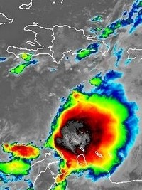
Haiti - FLASH : Storm Franklin arrives from the South 22/08/2023 06:36:46
This Tuesday, August 22, 2023 at 5:00 a.m. the center of Tropical Storm Franklin was located at 14.8° North 70.3° West, or 405km South-West of Santo-Domingo and 465km South-East of Port-au-Prince . Franklin is moving northwest at nearly 5 km/h (3 mph) The system is expected to turn north today and a general northward motion is expected on Wednesday. On the forecast track, the center of Franklin is expected to reach the south coast of Hispaniola on Wednesday, cross the island and leave the north coast on Thursday. Maximum sustained winds are near 80 km/h (50 mph) with higher gusts. Some reinforcement is expected before Franklin reaches the island. Tropical storm-force winds extend outward up to 110 km from the center. A tropical storm warning is in effect for the entire southern coast of Haiti from Anse d'Hainault eastward to the Dominican border. Haiti remains on yellow alert. Franklin is expected to produce additional precipitation amounts of 2.5cm to 7.5cm (1 to 3 inches), with local maximums of 15cm (6 inches). In parts of Hispaniola, rainfall amounts of 12.5 to 25 cm (5 to 10 inches), with isolated higher amounts of up to 38 cm (15 inches), are expected through Wednesday. Tropical storm conditions are expected to begin in warning areas this evening and through Wednesday. The storm will raise water levels up to 1 to 3 feet above ground level along the immediate coastline near and to the east of where the center makes landfall in Hispaniola. According to the Hydro Meteorological Unit of Haiti (UHM), the center of tropical storm Franklin should begin to affect the entire southern peninsula of Haiti from Wednesday and then move up (according to models from Haiti) a little more on the Dominican Republic which should experience heavier rains. In Haiti, heavy downpours, spontaneous gusts of wind and heavy sea conditions are still expected first on the southern peninsula of the country as of Wednesday and could be generalized during the same day across the country. See also : https://www.haitilibre.com/en/news-40304-haiti-flash-storm-franklin-will-affect-haiti.html SL/ HaitiLibre
|
|


|
Why HaitiLibre ? |
Contact us |
Français
Copyright © 2010 - 2026 Haitilibre.com |