
|
|
||||||||||||||||||
| Download the revised decree and electoral calendar, published in the official journal |

|
|
|
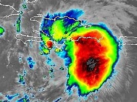
Haiti - FLASH : Storm Franklin enters Haiti, heavy rains expected 23/08/2023 06:27:05
Wednesday August 23, 2023, at 5:00 a.m. the center of storm Franklin was located at 17.4° North, 71.3° West, i.e. 90km southwest of Barahona, 225km southeast of Belle-Anse and 168km southeast of Port-au-Prince. Franklin is moving north at nearly 10 mph (17 km/h), and a north/northeastward motion is expected for Thursday, followed by a northeasterly turn on Thursday, the center of Franklin is expected to cross the island of Hispaniola on Wednesday and leave the island overnight Wednesday through Thursday. Maximum sustained winds are near 80 km/h (50 mph) with higher gusts. Some weakening is likely today as Franklin moves across the island, followed by strengthening from Thursday after the center moves over the Atlantic. Tropical storm-force winds extend outward up to 185 km (115 miles) from the center. The Hydro Meteorological Unit of Haiti recalls that the level of Yellow Vigilance (i.e. risk of impact of low to moderate intensity) is maintained in the face of threats of heavy rains and strong winds with risks of landslides, strong swells, landslides and flooding that the storm could cause during its passage on the southern peninsula of Haiti. The Hydro Meteorological Unit of Haiti indicates that according to the latest trajectory forecasts, the storm will cross the eastern part of the island during the day, which means that several of our forecast models are consistent with what the most heavy rains linked to the disturbance could go much further towards the Dominican Republic. However, the convective cells associated with Franklin could generate torrential rains, spontaneous gusts of wind and heavy sea conditions over the south of the country during this Wednesday. See also : https://www.icihaiti.com/en/news-40318-icihaiti-storm-franklin-last-straight-line.html https://www.haitilibre.com/en/news-40313-haiti-flash-storm-franklin-arrives-from-the-south.html https://www.haitilibre.com/en/news-40312-haiti-flash-storm-franklin-haiti-on-yellow-alert.html https://www.haitilibre.com/en/news-40304-haiti-flash-storm-franklin-will-affect-haiti.html HL/ HaitiLibre
|
|


|
Why HaitiLibre ? |
Contact us |
Français
Copyright © 2010 - 2026 Haitilibre.com |