|
||||||||||||||||||
|
|
Haiti - ALERT : Hurricane Tomas hits Haiti 05/11/2010 08:49:27
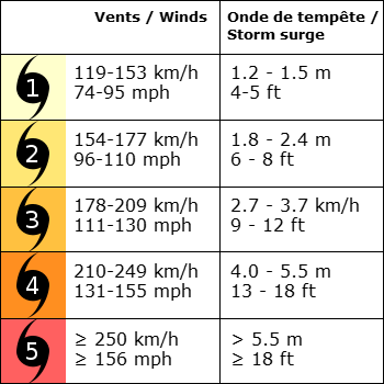
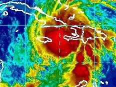
The hopes that Tomas remains a tropical storm have collapsed, as provided in our news yesterday, Tomas turned into a Category 1 hurricane (winds of 119-153 kph (74-95 mph)) at 2:00am Friday and hit Haiti. The government, banks, businesses, embassies and airlines are closed (more details to come). Civil Protection advises that in the temporary shelters, there will not be enough seats for everyone, priority will be given to those most vulnerable including the elderly, infants, pregnant women and sick . n Port-au-Prince, 42 camps have been identified at risk and represents more than 400,000 people. Most of the refugees refuse to leave the camps "We have not taken precautions. We are in God's hands," said Lise Mesila Ave. Patrick Joseph of Civil Protection said that people living in coastal areas are most at risk.  Location of Hurricane Tomas at 7:00 this morning (Haiti time): The center of Hurricane Tomas (Category 1) was located at 18.8 degrees north and 74.97 degrees West. At 255 km west of Port au Prince (160 miles) with sustained winds of 135 km/h (85 mph). Tomas is currently moving at 16 km/h (10 mph) along a path Northeast. The area of influence of winds extending up to 220 km (140 mi) and varies depending on the strength of the hurricane. Following the current trajectory, the hurricane center Tomas is located at: 64 km (40 mi) of Jérémie 120 km (75 mi) of Les Cayes 214 km (133 mi) of Saint-Marc 255 km (160 mi) of Port-au-Prince 237 km (148 mi) of Jacmel 237 km (147 mi) of Kingston (Jamaica) 130 km (80 mi) of Guantanamo (Cuba) If the planned trajectory and speed of Tomas do not change on Friday at 2pm Tomas will be: 129 km (80 mi) of Jérémie 177 km (110 mi) of Cayes 147 km (91 mi) of Saint-Marc 217 km (135 mi) of Port-au-Prince 226 km (140 mi) of Jacmel 180 km (112 mi) of Cap Haïtien 133 km (83 mi) of Gonaïves 55 km (34 mi) of Môle Saint-Nicolas Hurricane Tomas will pass, during the day (between this morning is this afternoon 14:00) at: 114km (71mi) of Port-de-Paix 194km (120mi) of Léogâne 109km (68mi) of the island of Gonâve As we previously mentioned, the danger of Tomas does not come from the strength of its winds, but the importance of its precipitation and its slow movement. According to available forecasts, Tomas could produce on a large portion of Haiti, an accumulation of total rainfall of 127-254 mm (5-10 inches). 1 mm of rain corresponds to 1 liter of water by square meter. In some isolated places, precipitations could reach up to 381 mm (15 inches). These rains could cause mudslides in the mountainous terrain, mudslides, landslides and cause flood and major flooding. See also : https://www.haitilibre.com/en/news-1581-haiti-tomas-first-victim-of-the-storm.html https://www.haitilibre.com/article-1571-haiti-tomas-double-risque-pour-haiti.html S/ HaitiLibre
|
|
|
Why HaitiLibre ? |
Contact us |
Français
Copyright © 2010 - 2024 Haitilibre.com |


