
|
|
||||||||||||||||||
| Download the revised decree and electoral calendar, published in the official journal |

|
|
|
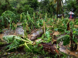
Haiti - Agriculture : The scale of the disaster accurate in the Great South 17/10/2016 10:27:00
Following a very grim picture of the agricultural sector https://www.haitilibre.com/en/news-18900-haiti-agriculture-very-grim-picture-of-the-agricultural-sector.html , the Ministry of Environment communicated a second report updated with new information to better measure the extent of the disaster. According to Simon Dieuseul Desras, Minister of the Environment, who always speaks of provisional assessment, nearly 75% of the ecosystem in Haiti have been damaged or destroyed by the passage of Hurricane Matthew and over 90% of the trees would have been uprooted or broken in the Nippes, Grand Anse and the South. he banks of many rivers have been destroyed partially or completely include : Grande Anse riverbanks : Roseaux, Grande rivière de Jérémie, Rivière Glace and Voldrogue... Southeast riverbanks : Bainet, Côtes-de-Fer and Belle-Anse... Nippes riverbanks : Baradères, Grande rivière de Nippes... In South riverbanks : Acul du Sud, Les , Port-à-Piment and Cavaillon... According to the report "Post-Matthew preliminary assessment" of the Ministry, 17 of the 30 major watersheds (representing more than 12,000 km2, +/- 43% of the country) were damaged by Hurricane. Marine protected areas (over 87,000 ha) and terrestrial (over 47,000 ha) were also affected. Added to this is the loss of some water sources at the South departments of Grande Anse and Nippes, the loss of important areas of agricultural land and the disappearance or reduction in the area of several beaches... See also : https://www.haitilibre.com/en/news-18839-haiti-agriculture-heavy-preliminary-assessment.html SL/ HaitiLibre
|
|


|
Why HaitiLibre ? |
Contact us |
Français
Copyright © 2010 - 2026 Haitilibre.com |