
|
|
||||||||||||||||||
| Download the revised decree and electoral calendar, published in the official journal |

|
|
|
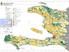
Haiti - Reconstruction : Country, departments and communes maps 15/02/2013 11:39:57
Among the tools of the territorial governance, cartographic representation of the current processes, occupies a prominent place. In partnership with the Ministry of Interior and local authorities and the National Centre for Geo Spatial Information (CNIGS), French Cooperation will release an album of maps of Haiti and providing all municipalities and departments of the Country of maps representing their territory. This book aims to meet the need of spatial knowledge essential for the planning and the implementation of all development projects and of planning. Thus, the layer of land use developed in 1998 by the CNIGS represents an information exceptional, true picture of the situation in the past that will allow all stakeholders and especially the local communities to measure the evolutions, to understand the phenomena in progress and to take decisions to balance trends. On this occasion, the French Institute of Haiti (IFH) offers an exhibition (Free) of those cards, on its premises from 14 to 19 February 2013, 99 rue Lamartinière in Port au Prince. Moreover, this Friday, February 15th at 7:00 pm, in the context of actions to support the decentralization process, the French Cooperation invites you to a presentation of maps of the country, departments and municipalities, conducted in partnership with the CNIGS and the Ministry of Interior and Local Authorities, which will be followed by a conference (Free admission) to the IFH, on the theme "Haiti : Between maps and territories", given by Professor Jean Marie Theodat, geographer, Professor of Geography at the University of Paris-Sorbonne and international technical expert in support of higher education from the State University of Haiti (UEH). HL/ HaitiLibre
|
|


|
Why HaitiLibre ? |
Contact us |
Français
Copyright © 2010 - 2026 Haitilibre.com |